What Happened
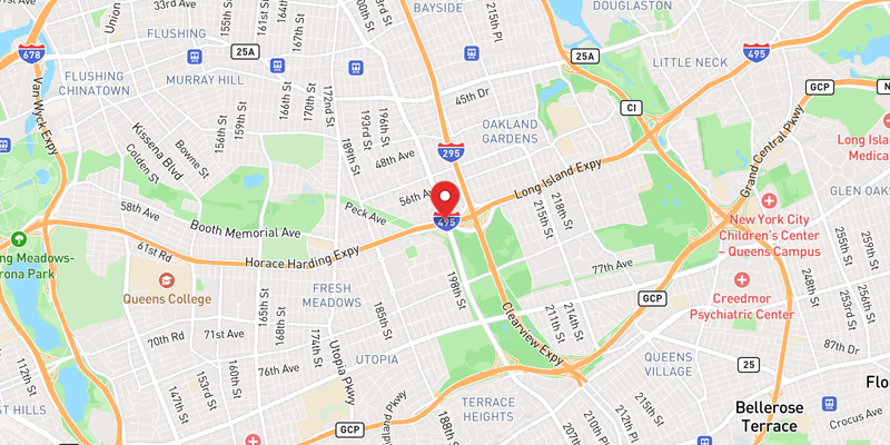
All westbound lanes of Interstate 495 — the Long Island Expressway — were brought to a complete standstill by flooding in Queens County on Saturday, July 18, 2026. The blockage was classified as a major-severity incident, with every lane of westbound travel halted. No specific time of onset or clearance was immediately available, though the closure unfolded on a day that saw an extraordinary cluster of water-related disruptions across the entire I-495 corridor.
Saturday’s flooding was not an isolated event. Long Island Traffic’s incident database recorded at least four separate flooding incidents on I-495 on July 18, 2026 — two of which were rated moderate in severity and at least one (this closure) rated major, with all lanes blocked. Two additional crashes on the expressway the same day were rated minor. The sheer volume of incidents points to a widespread precipitation event that overwhelmed drainage infrastructure along the length of the corridor.
In addition to the flooding closures, planned overnight construction shutdowns of the LIE and Sunrise Highway were announced to begin the week of July 18, 2026, adding further complexity for commuters already navigating water-related delays. That scheduled work represents a separate disruption; details are available in the related incident report.
No injuries, vehicle damage figures, or responding agency names were included in the initial incident record. Police have not yet confirmed additional details about the cause or precise timeline of the flooding event.
Location & Road Context
Interstate 495 westbound in Queens County is one of the busiest and most congested stretches of highway in the entire New York metropolitan area. The LIE serves as the primary east-west artery connecting Long Island to Midtown Manhattan via the Queens–Midtown Tunnel, meaning a full all-lanes blockage in the westbound direction carries immediate, cascading consequences for drivers heading into the city. Long Island Traffic’s database lists 1,752 recorded incidents on I-495, underscoring the corridor’s persistent vulnerability to both crash-related and weather-related disruptions. Queens County accounts for 173 recorded accidents in our local incident database.
Low-lying sections of the LIE in Queens are historically susceptible to flash flooding during heavy rain events, as storm drain capacity along older urban segments of the highway can be quickly overwhelmed. When all westbound lanes are blocked, drivers typically divert to the Grand Central Parkway, the Jackie Robinson Parkway, or local Queens surface streets — all of which experience significant secondary congestion under such conditions.
Broader Impact
The simultaneous occurrence of at least four flooding incidents along I-495 on July 18, 2026 — combined with two crashes and a separate announcement of upcoming overnight LIE and Sunrise Highway construction closures — signals a particularly difficult travel day for Long Island and Queens commuters. Drivers heading westbound toward the city should monitor real-time conditions through 511NY and allow for significantly extended travel times whenever heavy rainfall is forecast along this corridor. Related flooding incidents from the same day can be tracked at Flooding on I-495 (moderate, incident 1) and Flooding on I-495 (moderate, incident 2).