Storm update — May 21, 2026 (4:30 PM). NYC DEP officially confirmed the sewer system was hit with 6 inches/hour vs. its 1.75”/hour design capacity — a 340% overload. A 4th sinkhole opened in Brooklyn at Classon Ave & Park Ave. See compilation video below. The severe thunderstorm that hit NYC and Long Island on the evening of May 20 has passed. PSEG Long Island has restored power to all but 568 customers (down from 10,700+ at peak). LIRR is running normally. LaGuardia Runway 4/22 is expected to reopen at 10 AM Thursday. No new road closures or flooding. Scroll down for the full timeline of last night’s 20+ incidents.
Day-After Updates {#day-after}
4:30 PM Thu May 21 — NYC DEP Confirms 340% Sewer Overload + 4th Sinkhole + Flooding Compilation
Three major developments since last night:
- NYC DEP official confirmation: The sewer system was designed for 1.75”/hour. Last night’s storm delivered 6”/hour — a 340% capacity exceedance. @NYCWater (156 likes)
- 4th sinkhole in 8 days: Classon Ave & Park Ave in Brooklyn — NYPD on scene. The lag window we predicted is already producing results.
- Viral aftermath: Subway waterfall video (192 likes), “Nobody is telling you how fucked NYC’s infrastructure is” (203 likes), woman swept off feet by floodwater (42 likes)
Source: @SirajNoorani flooding compilation
Latest Reports — May 20 Night (newest first)
5:02 AM (Thursday) — ⚡ PSEG Near-Full Restoration: 568 Customers Remain Without Power
By 5:01 AM Thursday, PSEG Long Island had reduced active outages to just 568 affected customers across 25 outage events — down from a peak of more than 10,700 during Wednesday night’s severe thunderstorm. System reliability is reported at 99.95%. The MyPower Map banner still reads “Crews responding to outages caused by severe thunderstorms,” but the bulk of the work is done.
For context, ~568 customers without power is within normal range for PSEG Long Island on any given weekday morning. The overnight restoration represents a rapid recovery from the storm’s peak impact.
All other conditions remain stable as of the 5:02 AM scan:
- LIRR: No service disruptions reported. Normal early-morning schedule.
- LIE / Southern State / Northern State / Belt Parkway: No active closures reported. Residual wet pavement from overnight rain.
- LaGuardia Runway 4/22: Still closed. Port Authority targeting 10 AM Thursday for reopening. No announcement from @LGAairport since the original 11 AM Wednesday closure post. Travelers should plan for continued single-runway operations until that confirmation comes.
- Long Island: No new storm incidents, downed trees, or flooding reports since the 4:32 AM scan.
Source: PSEG Long Island MyPower Map — last updated 5:01 AM May 21, 2026
4:32 AM (Thursday) — 📊 Storm Quantified: ~6 Inches of Rain; F Train Was Suspended; Woman Swept Away Video Circulating
Overnight documentation is adding hard numbers to last night’s storm. A post by @MarioNawfal — now at 136,000 views — describes New York City as “underwater after heavy rainfall triggered flash flood warnings across the boroughs, with some areas receiving over 6 inches of rain in just a few hours.” The post explicitly confirms two key facts: the Long Island Expressway was shut down in both directions (covered in the 9:15 PM entry below) and that F train service was suspended during peak flooding.
The F train suspension is notable for Long Island readers: the line runs through Forest Hills and Jamaica before terminating at Jamaica/179 St — a gateway neighborhood at the Queens-Nassau border and a major LIRR transfer point. Suspension of service effectively severed subway access to eastern Queens and cut off a key car-free corridor toward Nassau County during the storm’s peak.
Separately, a video posted within the past hour on X shows a woman being swept away by floodwaters in NYC after heavy rain — struggling to hold onto a railing before being carried into the street. The clip has been widely reshared but has not been independently verified for location or specific timing. It is consistent with last night’s documented flooding conditions across Brooklyn and Queens.
As of 4:32 AM, no new incidents have been reported on Long Island — no PSEG outage spikes, no LIRR service disruptions, no road closures. Conditions remain stable across Nassau and Suffolk County. Thursday brings lingering showers; saturated ground keeps downed-tree risk elevated through the afternoon commute.
Source: @MarioNawfal on X · @Plugtv_kenya on X · @thepagetody on X
3:32 AM (Thursday) — 🌊 South Ozone Park: Basements and Streets Still Flooding
As of 3:31 AM Thursday, South Ozone Park in Queens is still seeing active flooding. Video shared by @WarMoni_tor, with footage credited to @RichDavidNYC, shows water entering basements and inundating streets. South Ozone Park — a low-lying neighborhood in southern Queens near the Belt Parkway and JFK Airport — is among the most flood-prone areas in the borough, with a combined sewer system that overtops in intense rain events.
The flooding appears to be residual from Wednesday night’s severe thunderstorm, which dropped roughly 2 inches of rain in under an hour across parts of Queens and Brooklyn. With no new storm cells on radar, water levels should recede through early morning, but residents with vulnerable basements should check sump pumps. NYPD (Queens South) is the responding agency for any road hazards or rescues.
Source: @WarMoni_tor on X, footage by @RichDavidNYC
1:32 AM (Thursday) — 🌧️ Storm Cleared; Overnight Status Check
The severe thunderstorm system has fully exited Long Island. Conditions as of 1:32 AM Thursday, May 21:
- Storm system: Cleared. Overnight showers possible, but the main event is over. Saturated ground keeps downed-tree risk elevated through Thursday afternoon — avoid parking under trees.
- LaGuardia Airport: Runway 4/22 still closed per FAA NOTAM through at least 10 AM Thursday. Repair crews on site overnight. All LGA traffic using Runway 13/31 exclusively. JFK remains the best alternate for Memorial Day travelers.
- PSEG Long Island: Approximately 2,500 customers still without power as of midnight, scattered across the service area. Crews working overnight. Text OUT to PSEGLI (773454) or check the outage map.
- LIRR: No new storm disruptions reported. Service running as restored after Tuesday’s strike. Expect normal early-morning schedule.
- NWS: Flood advisory in effect for Brooklyn, Staten Island, Queens, and Manhattan through the overnight hours. Do not drive through standing water.
- Thursday outlook: Showers likely, highs in the low 60s — a 30°F drop from Wednesday’s peak. Morning commuters should allow extra time for residual tree debris and wet roads.
No new major incidents reported across Nassau or Suffolk County since midnight.
12:28 AM (Thursday) — 🌊 Overnight Flooding: Jamaica, Bayside, Rosedale Queens + Kings Highway Tree Down
The tail end of Wednesday’s severe thunderstorm left additional flooding across Queens and Brooklyn well into the early hours of Thursday, May 21:
- Jamaica, Queens: Floodwaters inundated 100-32 204th Street, with video showing vehicles unable to pass. Jamaica’s storm sewer system — already notoriously strained — was overwhelmed. This is just steps from the Nassau County line; water levels here directly foreshadow conditions in western Nassau.
- Bayside, Queens: Flash flooding reported along multiple streets in Bayside, in northeastern Queens near the Nassau border and the Cross Island Parkway. Bayside floods reliably in intense rain events due to its proximity to Little Neck Bay and inadequate catch basin capacity.
- Rosedale, Queens: Community activist Carl Patterson shared video of flooded streets in Rosedale — a low-lying neighborhood at the very edge of Queens along the Nassau County line. When Rosedale floods, Elmont and Valley Stream are typically minutes behind.
- Kings Highway, Brooklyn: A massive tree fell and blocked the intersection at 501 Kings Highway, according to Citizen App footage. No injuries reported. This intersection serves as a major local artery in Flatbush — expect residual lane closures into the Thursday morning commute as Parks Department crews clear debris.
The National Weather Service issued a flood advisory for Brooklyn, Staten Island, Queens, and Manhattan urging people to avoid driving or walking into flooded roadways. Thursday will bring lingering showers with a 30-degree temperature drop to the low 60s — saturated soil means downed-tree risk remains elevated well into the afternoon.
Source: ABC7 / WABC Eyewitness News
12:02 AM (Thursday) — 📊 MTA Board Approves 13% Refund for LIRR Monthly Ticket Holders
While Long Island was still cleaning up from the storm, the MTA Board voted Wednesday afternoon to approve a 13% refund for all LIRR customers who hold May monthly tickets — compensation for four days of suspended service during the May 16–19 strike. The refund will be automatically applied to the payment method on file. No action required.
The math: 4 days out of 31 in May equals approximately 12.9%, rounded to 13%. On a standard monthly, that’s a credit of roughly $26–$65+ depending on fare zone. Weekly and daily ticket holders are not included.
Full breakdown: MTA Board Approves 13% Refund for LIRR Monthly Holders →
Source: @LIRR on X
9:45 PM — ⚡ PSEG OFFICIAL: 10,700+ Customers Hit — 2,529 Still Without Power as Crews Deploy Overnight
PSEG Long Island issued its official storm update at 9:45 PM Wednesday:
“Tonight’s storm has downed trees, branches and wires, affecting more than 10,700 of 1.2 million electric customers across Long Island and the Rockaways. As of 9:30 PM, power has been restored to more than 8,100 customers. As of 9:41 PM, 2,529 customers are without power. Outages are scattered across the service area. Crews will work throughout the night safely and as quickly as possible until all outages are restored.”
The numbers tell the story: PSEG restored power to roughly 76% of affected customers within hours of the storm’s passage — a faster recovery than the utility’s broader reliability metrics might have suggested. The remaining 2,529 customers are scattered, not concentrated in one area, making restoration labor-intensive as crews track each individual outage.
Reporting an outage: Text OUT to PSEGLI (773454) or visit the MyPower outage map for crew locations and estimated restoration times.
Source: @PSEGLI on X
11:32 PM — ✈️ LaGuardia Runway 4/22 Repair Timeline Unclear: “6 AM” vs “10 AM” — Memorial Day Travelers Watch Closely
Confusion surrounds the reopening timeline for Runway 4/22 at LaGuardia Airport as repairs continue overnight. A verified pilot on X (@allan_orson) stated at 11:05 PM that crews “hope to have it back open by 0600” — but the official Port Authority / FAA NOTAM issued earlier Wednesday puts the closure through Thursday 10 AM, subject to change if weather or repairs run long.
The discrepancy may reflect real-time progress: if the excavator work is going faster than expected, reopening by 6 AM is possible. But with overnight thunderstorms still in the area, ground softening could slow repairs. The safest assumption for Memorial Day travelers is 10 AM — with the chance of a pleasant surprise.
As of 11:30 PM, all air traffic at LGA is using Runway 13/31 exclusively. Arriving passengers should use JFK as their alternate booking option tonight.
Source: @allan_orson on X · Port Authority / LaGuardia Airport
11:00 PM — ⚡ LIGHTNING STRIKES LONGWOOD HIGH SCHOOL IN YAPHANK — Gymnasium Ceiling Fire, Storm Passes Long Island
The severe thunderstorm has cleared Long Island, but not before leaving its mark on Yaphank in central Suffolk County: a bolt of lightning struck Longwood High School, sparking a fire in the gymnasium ceiling. The Yaphank Fire Department was still battling the blaze at 10:15 PM, according to Suffolk County Fire Rescue and Emergency Services. No injuries reported — the building was unoccupied.
The storm watch expired at 9 PM. PSEG Long Island reports near-100% power restored as of ~9:30 PM. Minor road flooding and scattered downed trees were reported across Nassau and Suffolk, but Long Island avoided the catastrophic infrastructure failures that hit NYC earlier in the evening. Earlier, lightning struck multiple trees on Shelter Island, some reported on fire, with localized outages.
Thursday outlook: showers likely, highs in the low 60s — a 30-degree temperature drop from today’s peak. Saturated soil means tree-failure risk remains elevated through Thursday.
Full story: Lightning Strikes Longwood High School — Suffolk County Storm Aftermath →
10:32 PM — ⚡ PSEG Long Island’s Reliability Got WORSE Before This Storm — And Executives Got Bigger Bonuses
As Long Island braces for the overnight hours of tonight’s severe thunderstorm, Newsday published a damning reliability report today: PSEG Long Island’s outage frequency has worsened by nearly 12% since 2021, with the system average interruption frequency index rising from 0.679 to 0.759 — even as executive bonuses climbed significantly in 2025. Average outage duration is barely better than it was four years ago: 82 minutes per incident.
In plain terms: you’re losing power more often, and when you do, it takes about as long to get it back. Tonight’s 60 mph winds and lightning strikes are now stress-testing a grid that, by PSEG’s own numbers, is trending in the wrong direction.
Key facts for tonight:
- Outage report hotline: 1-800-490-0075
- PSEG Long Island outage map
- Heavy rain continues tracking east across Long Island until approx. 2 AM Thursday
- Eastern Suffolk (Babylon to Riverhead to Hamptons) still in the direct storm path
Full analysis: PSEG Long Island’s Worsening Reliability Faces Its Biggest Test →
9:54 PM — 🚨 LaGuardia Storm + Sinkhole = Memorial Day Travel Catastrophe — Cancellations Spreading to Chicago, Atlanta, Dallas
The compounding crisis at LaGuardia Airport is now one of the biggest travel disruptions in the region’s recent history, heading into Memorial Day weekend:
- Runway 4/22 remains closed until at least Thursday 10 AM after a sinkhole was found during routine inspection at 11 AM Wednesday
- 101 flights canceled, 139 delayed as of 4 PM — those numbers have climbed through the evening as the severe thunderstorm added further pressure on single-runway operations
- Nationwide cascade: disruptions have spread to Chicago O’Hare, Atlanta Hartsfield, and Dallas-Fort Worth as delayed LGA aircraft ripple through carrier networks
- Memorial Day weekend timing: Port Authority was already bracing for 2+ million passengers through NY-area airports this weekend — the sinkhole closure and storm create a structural backlog that won’t clear overnight
- This is Runway 4/22 — the same strip where an Air Canada jet killed two pilots in a ground collision in March 2026
- LaGuardia was built on reclaimed marshland; geologists and infrastructure experts have warned for years about subsurface instability beneath the aging airfield
For Long Island travelers: JFK is the best alternate. If your airline issued a travel waiver, use it now — don’t wait standby in a chaotic terminal. Thursday morning road access via LIE/Van Wyck may still have residual flooding from tonight’s storm.
Full analysis: LaGuardia Sinkhole + Storm = Memorial Day Nightmare →
Flight status: FlightAware LGA | FAA: fly.faa.gov
9:24 PM — Staten Island Hammered: SIR Suspended, Outerbridge Crash, Trees Down, Hundreds Lose Power
The severe thunderstorm swept through Staten Island Wednesday evening with 60 mph wind gusts, triggering a cascade of infrastructure failures across the borough:
- Staten Island Railway suspended between Prince’s Bay and New Dorp — a tree fell on the tracks near Annadale. No service restoration ETA. The SIR is a single-line system; there is no alternate service.
- Outerbridge Crossing: A crash is blocking all lanes on the bridge connecting Staten Island to Perth Amboy, NJ. Use Goethals or Bayonne bridges as alternates.
- Downed trees reported at Chess Loop (Richmond), Giffords Lane (Great Kills), and Clove Road/Forest Ave (West Brighton) — one tree crushed an unoccupied car. Wires down on Forest Avenue.
- Power outages: 600+ customers hit in Arden Heights (since restored); ongoing outages in Mariners Harbor, Graniteville, West Brighton, Oakwood Heights, and New Springville.
With the ferry running as the only reliable Manhattan connection, Staten Island residents are effectively cut off from multiple directions tonight.
Full story: Staten Island Storm — Trees Down, SIR Suspended, Outerbridge Crash →
Outages: Con Edison outage map | SIR status: MTA alerts
8:54 PM — Storm Crosses Into Nassau County; LIRR Under Pressure on First Night Back from Strike
The severe thunderstorm watch remains in effect for Nassau and Suffolk Counties through 9 PM. The storm has crossed from NYC into Long Island, with 60-70 mph wind gusts, large hail, and flash flooding possible across the island.
The timing couldn’t be worse for Long Island Rail Road riders: trains returned just 36 hours ago after a 4-day strike, and tonight’s storm is the first major weather test for a system still re-normalizing operations. Downed trees, flooded grade crossings, and PSEG Long Island outages affecting signals are all active risks. Simultaneously, NJ Transit has suspended service into Penn Station due to a brush fire near the Hudson tunnels — compounding platform congestion for LIRR trains sharing the terminal.
Full analysis: LIRR’s First Night Back from Strike Hits Severe Storm →
Monitor: MTA LIRR alerts | PSEG Long Island outage map
10:13 PM — 🔥 LIGHTNING STRIKES TREES ON FIRE + POWER OUTAGES — Shelter Island, Suffolk County
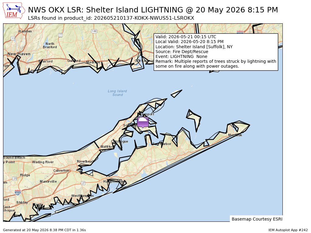
The storm has reached eastern Long Island. At 8:15 PM, the Shelter Island Fire Department reported multiple trees struck by lightning, some on fire, along with power outages. Shelter Island sits between the North and South Forks — if lightning is hitting there, Greenport, Southold, Sag Harbor, and the Hamptons are in the direct path.
Source: IEMBot New England / NWS — Suffolk Co Fire Dept/Rescue report #nywx
10:05 PM — ⚠️ STORM TRACKING EAST OVER LONG ISLAND — Heavy Rain Until 2 AM
Meteorologist Mike Wankum (@MetMikeWCVB): “Heavy rain moving through the islands. This will last until about 2am.” The storm cell has passed through NYC and is now tracking east directly over Long Island. Suffolk County residents from Babylon to Riverhead to the Hamptons should prepare for heavy rain, possible flash flooding, and continued wind through the overnight hours.
Source: @MetMikeWCVB
10:03 PM — Downed Trees + Power Lines in Ozone Park, Queens
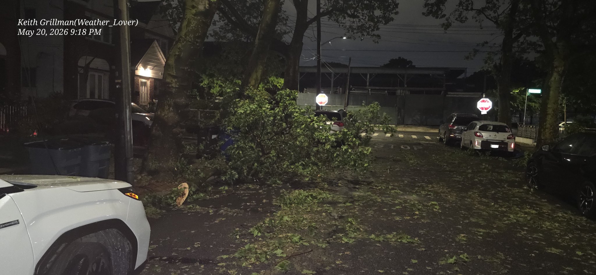
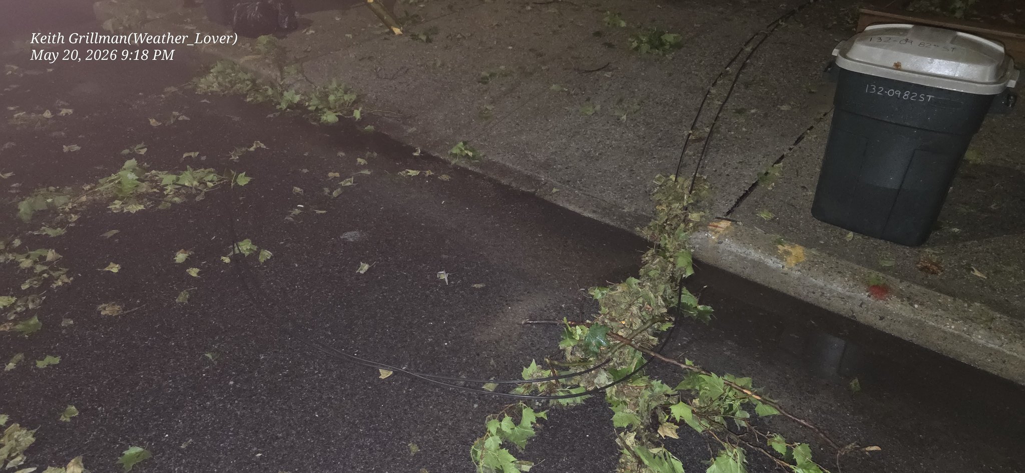
Downed tree branches and power lines in Ozone Park, Queens from the severe thunderstorm. Ozone Park is right at the Queens/Nassau border — this damage pattern is now reaching Long Island’s doorstep. Expect similar tree and wire damage across western Nassau County as the storm pushes through.
Source: @weather_lover (Keith Grillman) #NYwx
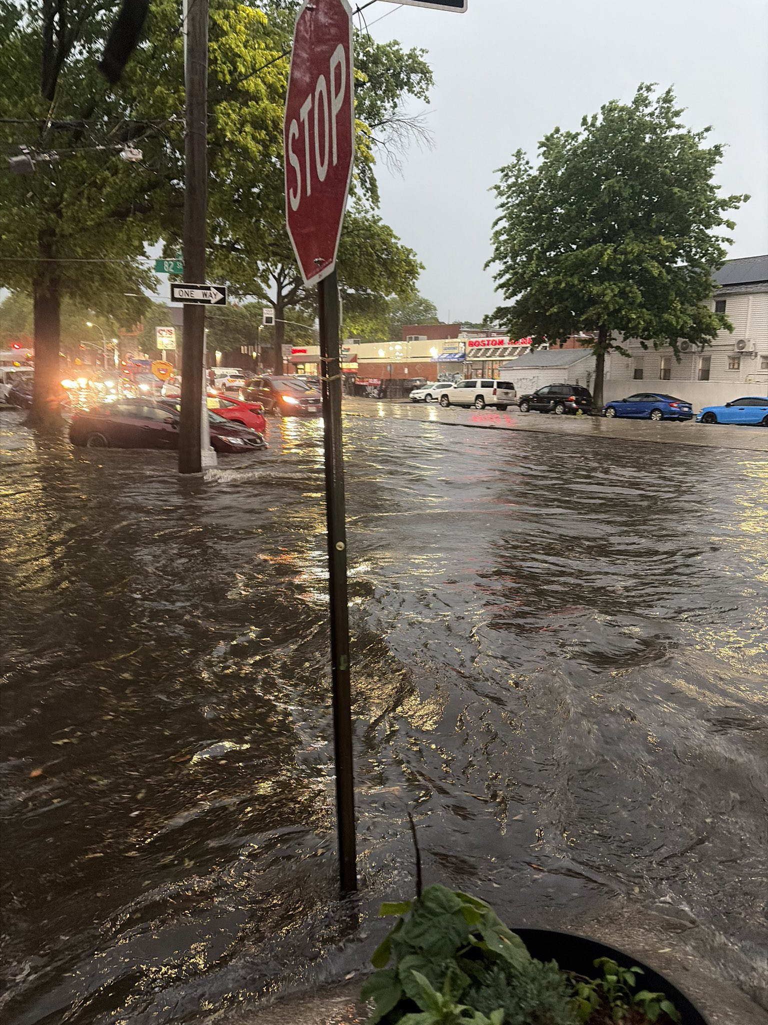
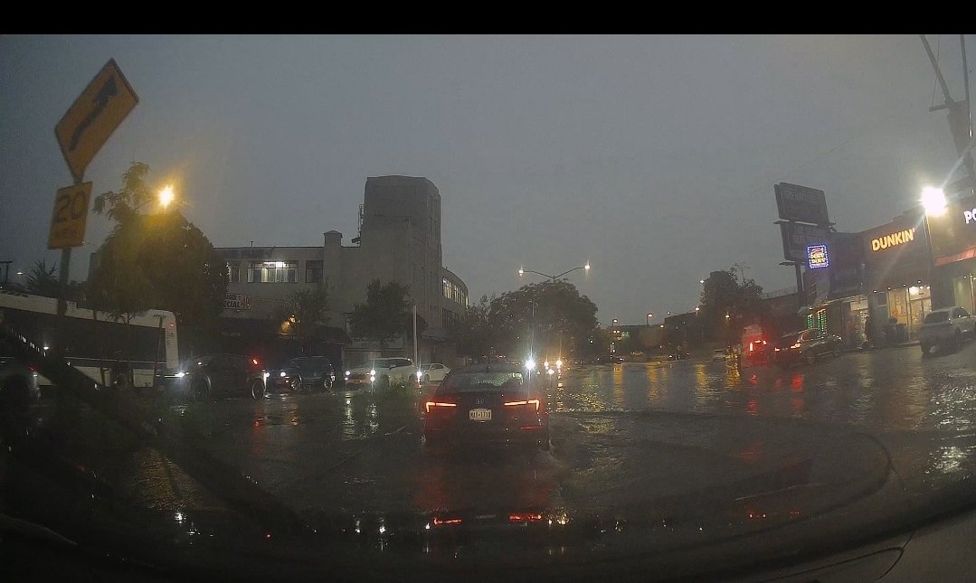
10:02 PM — NYC Streets Flooding + Lightning — “Avoid Unnecessary Travel”
General NYC flooding and lightning footage showing the scope of tonight’s storm. Heavy rain, flooded roads, downed wires. Avoid unnecessary travel across the metro area tonight.
Source: @PolishCuisine
10:00 PM — 🚨 CAR SUBMERGED on Jackie Robinson Parkway — Good Samaritan Rescues Trapped Occupants
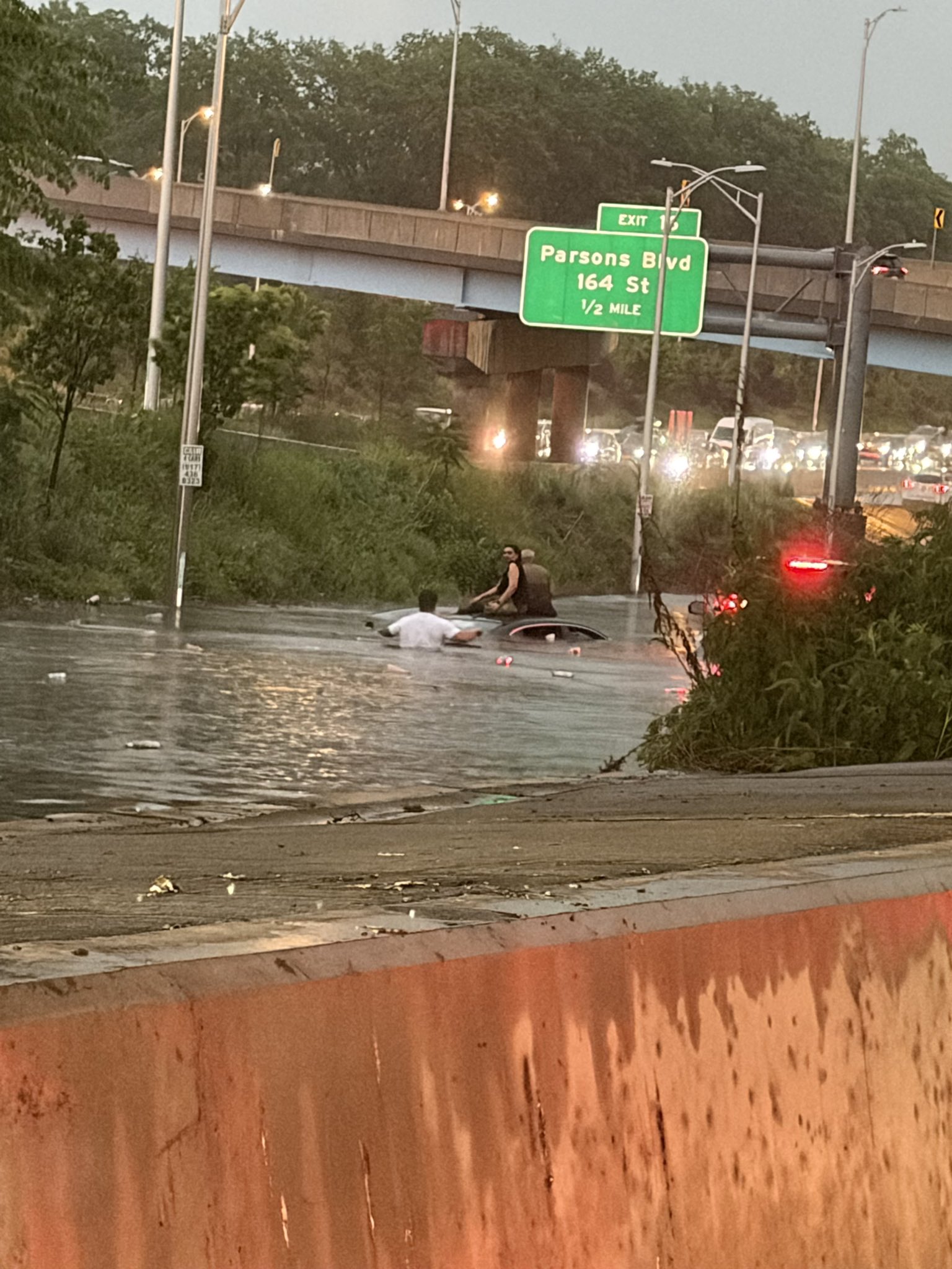
A car is SUBMERGED on the Jackie Robinson Parkway heading toward the Grand Central Parkway. Video shows a man getting out of his own vehicle to rescue the occupants of the flooded car. The poster writes: “~20 minutes of rain in NYC should not lead to complete infrastructure failure like this.”
The Jackie Robinson Parkway connects Queens to Brooklyn and is a major alternate route to the Grand Central Parkway — which feeds directly onto the LIE toward Long Island. With the LIE already flooded at 188th St, the Jackie Robinson flooded here, Atlantic Ave flooded, and Hillside Ave flooded — there is effectively no way to drive from Brooklyn/Queens to Long Island right now.
Source: @AmendAndRevise
9:58 PM — Atlantic Avenue Flooded in Brooklyn
Atlantic Avenue in Brooklyn — a major east-west artery that connects to the BQE and feeds into Queens — is flooded. Atlantic Ave is a key route for anyone heading from Brooklyn toward the Belt Parkway and Long Island. One more corridor knocked out tonight.
Source: @HypeDerek #nycstorm
9:25 PM — 🚨 “New Yorkers Are Underwater in Their Homes” — Merrick Ave & Liberty Ave, Queens
@Mikeyup10: “New Yorkers are underwater in their homes. No flash flood warnings from the @NYCMayor. How many people just died? FDNY is rushing around. Debris everywhere. Merrick Ave and Liberty Ave was a raging river an hour ago. Not a SINGLE emergency alert to anyone’s phone.”
This is a life-safety failure. Residents reporting water INSIDE their homes with no advance warning via Wireless Emergency Alert (WEA) or NotifyNYC push notification. FDNY is actively responding. Merrick Ave is a direct corridor to the Nassau County border — the flooding is pushing east toward Long Island.
Source: @Mikeyup10
9:13 PM — “Worst Flooding I Have Seen” — Hempstead Ave, Hillside Ave, Queens Village Underwater
@PassengersUnited: “Some of the worst flooding I have seen on Hempstead Ave in Queens Village. Thank god this bus operator got me home. Hillside Ave was even worse.”
Also reporting: “Hillside Ave from 168 all the way to Clear View Expressway was flooded. Side streets by IS 109 school flooded as well.” — calling on @LeroyComrie and @CMNantashaW to get resources from the Mayor’s office.
This is critical for Long Island commuters: Hillside Avenue and Hempstead Avenue are major alternate routes when the LIE is backed up. With the LIE also flooded at 188th St (see below), there are essentially no viable east-west routes through eastern Queens right now. If you’re trying to get to Long Island from the city — you can’t.
Source: @PassengersUnited on X
9:15 PM — 🚨 FLASH FLOODING CLOSES ALL LANES OF I-495 (LIE) IN QUEENS
The Long Island Expressway is BLOCKED IN BOTH DIRECTIONS at 188th Street in Fresh Meadows, Queens. All lanes closed due to flash flooding. This is the main artery connecting Long Island to NYC.
NWS reports flash flooding confirmed at 7:45 PM EDT, 1 mile NNW of Fresh Meadows. Radar estimates water rising fast enough to block all travel lanes.
If you are on the LIE heading west into Queens: EXIT NOW. Take the next available exit and use Northern State Parkway or Southern State Parkway as alternates. Do NOT attempt to drive through standing water on the LIE.
Source: NWS Flash Flood Report via IEMBot / @BransonWX
9:04 PM — Storm Hits Nassau-Suffolk Border — Video From the Front Line
“Heavy storm to the west headed toward the Nassau Suffolk line. Looks rough!” The storm cell that flooded Brooklyn and Queens is now crossing into central Long Island. This video and these photos show the wall of weather bearing down on the Nassau-Suffolk border. Residents from Melville to Huntington to Babylon should prepare for heavy rain, strong winds, and possible flash flooding in the next 30-60 minutes.
Source: @timelesslisa #nywx #longislandwx
8:50 PM — Person Critically Injured After Being Struck by Train — 2/5 Lines, 233 St, Bronx
A person was critically injured after being struck by a train near 233 St Station on the 2/5 lines in the Bronx, prompting a major emergency response and severe transit delays on the east side subway lines. This incident occurred earlier today and compounded the evening’s storm disruptions — the 2/5 lines serve as a key north-south connector for commuters transferring to Metro-North and LIRR at key hubs.
Source: @CitizenAppNYC
8:48 PM — 3,270 ConEd Customers Without Power in NYC
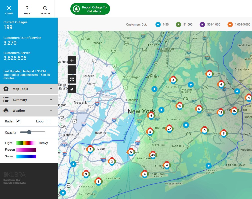
ConEdison is reporting 3,270 customers without power as of 8:45 PM as the severe thunderstorm’s 60 mph winds down power lines across the city. The outage map shows clusters in Brooklyn and Queens — the neighborhoods hardest hit by tonight’s flooding.
For Long Island: PSEG Long Island is the utility provider. Check the PSEG Long Island outage map as the storm crosses into Nassau and Suffolk. Report outages: 1-800-490-0075.
Source: @NYCEMSWatch
8:46 PM — NJ Transit Rail Service SUSPENDED Into Penn Station — Brush Fire Near Hudson Tunnels
@NJTRANSIT: “Due to a brush fire near one of the Hudson River Tunnels, NJ TRANSIT rail service is suspended into and out of Penn Station New York. Midtown Direct trains are being diverted to Hoboken.”
Long Island impact: This is a cascading failure. The brush fire — likely sparked by the severe thunderstorm’s lightning — has knocked out NJ Transit service through the Hudson River tunnels. Penn Station is shared infrastructure between NJ Transit and the LIRR. When NJ Transit operations are disrupted at Penn, it creates platform congestion, signal delays, and scheduling conflicts that ripple into LIRR service. Long Island commuters at Penn Station may face delays even if LIRR trains are technically running.
What to do: Check MTA LIRR alerts for real-time service status. If heading to NJ, NJ Transit Midtown Direct trains are diverting to Hoboken — take the PATH from 33rd St or WTC to connect.
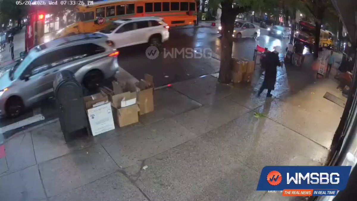
8:42 PM — Tree Branch Crushes Car in Williamsburg, Brooklyn
A large tree branch fell on a parked car at Lee Avenue and Rutledge Street in Williamsburg, Brooklyn. No injuries reported. The 60 mph wind gusts from tonight’s severe thunderstorm are snapping branches and downing limbs across Brooklyn.
Source: @WMSBG (Williamsburg News)
~8:35 PM — Dramatic Shelf Cloud Rolls Over Long Island
A massive shelf cloud formation was photographed and filmed over Long Island — signaling the storm’s arrival in Nassau County. “Haven’t seen a shelf cloud like this on Long Island probably ever,” the photographer noted.
~8:10 PM — Bushwick, Brooklyn: Streets Submerged
Flash flooding turned Wilson Avenue and Stockholm Street in Bushwick into a river. Water reached levels that would strand vehicles.
~7:30 PM — Queens: Flushing Avenue Underwater in Jamaica
Pedestrians waded through ankle-deep water on Flushing Avenue as Jamaica’s combined sewer system was overwhelmed.
~6:28 PM — NWS Issues Severe Thunderstorm Warning
The National Weather Service issued a warning for Brooklyn, Manhattan, and Staten Island: 60 mph winds and penny-sized hail until 7:00 PM. Storm pushing east toward Long Island.
Earlier Today — Two Sinkholes
- 11:00 AM: LaGuardia Airport Runway 4/22 shut down after sinkhole discovered during routine inspection. 101 flights canceled.
- ~3:00 PM: School bus with 39 children stuck in a sinkhole on E 180th St in the Bronx. No injuries reported. Full geological analysis: why Long Island and NYC have a sinkhole problem →
What to Report
If you see storm damage on Long Island — downed trees, flooding, power outages, road closures — report to:
- Emergencies: 911
- PSEG Long Island outages: 1-800-490-0075 or outage map
- Road hazards: 511NY or 511ny.org
- Non-emergency damage: 311
Full Storm Coverage
- MTA Board Approves 13% Refund for LIRR Monthly Holders
- LIRR First Night Back from Strike — Storm Hits
- LaGuardia + Bronx Sinkholes
- Dr. Dao: Long Island’s Sinkhole Geology
- Severe Thunderstorm Warning
- Queens Flooding — Flushing Ave
- Bushwick Flash Flood
- Shelf Cloud Over Long Island
- LIE Wrong-Way Driver + DWI
- Staten Island: Trees Down, SIR Suspended, Outerbridge Crash
Legal Resources — Storm Damage Claims
If tonight’s storm caused injury or property damage, you may have legal options — especially if municipal infrastructure failure (sewer backup, road flooding, no emergency alerts) contributed to your harm. New York law requires a 90-day Notice of Claim for claims against the city or county under General Municipal Law §50-e — missing that deadline can permanently bar the claim.
- Free consultation — Law Office of Jason Tenenbaum, P.C. — Long Island and NYC accident attorneys; 24+ years of practice, $100M+ recovered.
- What to do in the first 24 hours after an accident — preserve evidence, document the scene, file no-fault on time.
- Settlement calculator — estimate your claim — interactive tool calibrated for NY courts.
📞 (516) 750-0595 — Available 24/7
Sources
- @StatenIslandUSA on X — Outerbridge Crossing crash, downed trees, ConEd outages
- MTA Service Status — Staten Island Railway and LIRR alerts
- PSEG Long Island outage map
- National Weather Service — New York office — Severe Thunderstorm Warning issuance + radar imagery
- Newsday — PSEG-LI reliability report (May 20, 2026) — outage frequency and SAIFI data
- Port Authority — LaGuardia operations — Runway 4/22 closure + cancellation counts
- 511NY — real-time roadway alerts and closures
- ABC7 / WABC Eyewitness News — Overnight flooding coverage (12:28 AM Thursday) — Jamaica, Bayside, Rosedale flooding; Kings Highway tree down
- News 12 Long Island, ABC7 NY, CBS New York, NBC New York — local broadcast coverage of storm damage and infrastructure failures across the metro
- @WarMoni_tor on X / @RichDavidNYC — South Ozone Park street and basement flooding video, 3:31 AM Thursday
- The Traveler — LaGuardia sinkhole coverage (overnight) — Runway 4/22 repairs ongoing through Thursday AM; 5.6M Memorial Day traveler projection via Port Authority
- @MarioNawfal on X — ~6 inches of rain confirmed, LIE both directions closed, F train suspended; 136K views (4:32 AM update)
- @Plugtv_kenya on X — woman swept away by NYC floodwaters video; circulating at 4:32 AM (unverified location/timing)
- @thepagetody on X — “NYC Flash Floods Overwhelm NYC Streets” summary post, May 20-21, 2026
- PSEG Long Island MyPower Map — 568 customers without power as of 5:01 AM May 21, 2026; 25 active outage events; system reliability 99.95%
Last updated 5:32 AM Thursday, May 21. Storm Watch scan complete — all clear. PSEG Long Island near-full restoration (568 customers, 25 active outages as of 5:01 AM). LIRR normal. No new Long Island incidents. LaGuardia Runway 4/22 still closed; Port Authority 10 AM Thursday reopening target stands — no update from @LGAairport since 5 PM Wednesday. Thursday brings showers and a 30°F temperature drop to the low 60s — saturated ground keeps tree-failure risk elevated through the afternoon commute. 5.6 million travelers expected through Port Authority airports over the five-day Memorial Day period (Thu–Mon).